Tropical Storm Nana Continues Westward with Little Change in Strength2
Tropical Storm Nana Continues Westward with Little Change in Strength
At 6:00 am Tropical Storm Nana was located near latitude 17.1N, longitude 83.7W or about 305 miles East of Belize City. Maximum sustained winds were near 60 mph and the system was moving west at 18 mph. A tropical storm warning and a hurricane watch is in effect for the entire coastline of Belize. Tropical Storm Nana is expected to become a hurricane by tonight and the hurricane watch will likely be upgraded to a warning. The National Meteorological Service of Belize continues to closely monitor this system and urges the public to make the necessary preparations for the passage of this storm and stay informed with official information issued by the NMS and NEMO.
At 3:00 am Tropical Storm Nana was located near latitude 17.0N, longitude 82.7W or about 365 miles East of Belize City. Maximum sustained winds were near 60 mph and the system was moving west at 18 mph. A tropical storm warning and a hurricane watch is in effect for the entire coastline of Belize. Tropical Storm Nana is expected to become a hurricane by tonight and the hurricane watch will likely be upgraded to a warning. The National Meteorological Service of Belize continues to closely monitor this system and urges the public to make the necessary preparations for the passage of this storm and stay informed with official information issued by the NMS and NEMO.
Advisory #1 - Tropical Cyclone Development in the Central Caribbean
MEMO National Emergency Management Organization “Preserving Life and Property” ADVISORY # 1 (AMENDED VERSION) POTENTIAL TROPICAL CYCLONE DEVELOPMENT IN THE CENTRAL CARIBBEAN SUNDAY, 30TH AUGUST, 2020 as at 5:00 PM The National Meteorological Services of Belize and the National Emergency Management Organization (NEMO) hereby advises the general public that a westward-moving tropical wave is located over the eastern Caribbean Sea just west of the Windward Islands. Associated shower and thunderstorm activity continues to show signs of organization, and environmental conditions are expected to gradually become more conducive for development. A tropical depression is likely to form during the next day or two while the system moves westward at about 15 mph across the central Caribbean Sea. Interests in Jamaica, Honduras, Belize, Guatemala and Yucatan should monitor the progress of this disturbance. * Formation chance through 48 hours…high…70 percent. * Formation chance through 5 days…high…80 percent. The Met Service and NEMO will continue to monitor this system closely for development. It is possible that the system could start affecting Belize as early as Thursday. The public is advised to remain vigilant and to be prepared for possible storm arrival in accordance with your emergency plan. IF the need arises for you to relocate or evacuate, move early, know which shelter you will go to, and take along your essential necessities required for you to survive. If the islands need to evacuate, an announcement will be made. If people want to voluntarily relocate from the islands to the mainland prior to the announcement of a government coordinated evacuation those individuals most be cleared through MOH San Pedro where all particulars are recorded and checked against MOH COVE)-19 positive/persons quarantine list and a temperature check must be taken prior to departure. DUE TO THE SOE voluntary movement will have to be decided by the National Oversight Committee. In the event of a government coordinated evacuation the following protocols must be followed, a headcount, particulars recorded, names check against the MOH COVID-19/Quarantine list and a temperature check will be taken prior to departure. If anyone is known to be COVE) positive or under quarantine, the San Pedro Emergency Committee first option is for those individuals to be housed/sheltered on the islands. The workforce on the island is at minimal levels or nonexistent and there are no tourists. If a voluntary relocation and a government coordinated evacuation have to be done, the wearing of masks, social distance on the vessels and buses, and temperature checks will be done prior to departure as we did during the first COVE) 19 wave in San Pedro. If we have to evacuate COVID-19 positive and they will need shelter certain shelters in all municipalities will be declared COVE)-19 HURRICANE SHELTERS as per a quarantine centre where people will be housed/sheltered. For those individuals who are COVID-19 positive and don’t need shelter but under the SOE would have to be in quarantine or be in self-isolation, the Ministry of Health will have to direct that such is carried out. The names of those persons leaving the islands will be shared between the Ministry of Health San Pedro and the Ministry of Health in the receiving communities; again this was done before during the first COVE) 19 wave in San Pedro. Once in a shelter everybody must wear a mask, people showing symptoms will be contained in a separate section of the building, hand washing /sanitizing must be done before entering the shelter. Shelter Wardens and Managers will allocate shelter space as social distance must be adhered to and the shelter must be sanitized on a regular basis. COVE) 19 PROTOCOLS and SI 119 of 2020 shall be adhered to. The elderly and persons with underlying health conditions must not occupy the same space with normal persons. Shelter Managers must monitor and correct hygiene and cough /sneeze etiquette not done properly. The Ministry of Health (MOH) staff and or authorized volunteers will conduct daily monitoring of shelters to detect people who are sick. The Shelter Management Team (Public Officers/ Volunteers) MUST wear/use PPE (Masks, Gloves, coverall (optional), thermometers). NEMO’s important contact information is attached. NEMO will keep the general public updated on any further developments. The public is advised to stay alert. Please adhere to the official release from the National Met Service and NEMO. …Ends…
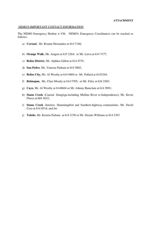
ATTACHMENT
NEMO’S IMPORTANT CONTACT INFORMATION
The NEMO Emergency Hotline is 936.
NEMO’s Emergency Coordinators can be reached as follows:
a) Corozal. Mr. Ronnie Hernandez at 614 7140;
b) Orange Walk, Mr. Aragon at 615 2264; or Mr. Leiva at 614 7177;
c) Belize District, Mr. Alphius Gillett at 614 4735;
(d) San Pedro, Ms. Vanessa Parham at 614 5865;
e) Belize City, Mr. Al Westby at 614 8604 or Mr. Pollard at 6143244;
f) Belmopan, Ms. Clare Moody at 614 5705; or Mr. Eiley at 624 2365;
g) Cayo, Mr. Al Westby at 6148604 or Mr. Johnny Ramclam at 614 5891;
h) Stann Creek -Coastal- Dangriga including Mullins River to Independence), Mr. Kevin Flores at 604 3632;
i) Stann Creek -Interior- Hummingbird and Southern highway communities, Mr. David Cruz at 614 8514; and for
j) Toledo, Mr. Kenton Parham at 614 2158 or Mr. Dennis Williams at 614 2393
Advisory #4 NEMO DECLARES A HURRICANE WATCH FOR BELIZE
TROPICAL STORM NANA APPROACHING BELIZE EXPECTED TO BECOME A HURRICANE BEFORE LANDFALL
TUESDAY, 1ST SEPTEMBER, 2020 as at 4:30 PM
The National Meteorological Services of Belize and the National Emergency Management Organization (NEMO)advise that Tropical Storm Nana was located near latitude 16.8N, longitude 79.3W or about 590 miles east of Belize City. Nana was moving to the west at 18mph with maximum sustained winds of 50mph. Nana is forecast to continue moving west and to make landfall on Thursday as a category one hurricane. Residents across the country should be prepared for category 1 hurricane force winds between 74 and 95 mph. This system could also produce rainfall of up to 4-6 inches across the country which could lead to flash flooding and possible landslides. The NMS of Belize will continue to monitor the system and update the NEMO and the general public accordingly. The public must monitor the progress of this system but do not panic!
NEMO hereby declares a HURRICANE WATCH for Belize (one red flag with a black centre), Belize City, and the Cayes are under a Tropical Strom WARNING. The Warning is declared as the system path puts those areas under direct threat. Associated heavy rains can cause flooding, washout roads, bridges, culverts, winds can damage homes, trees branches, power lines and poles, loose items can be blown about and storm surge can cause flooding, drowning and beach vessels not securely moored. The next declaration is expected to be a Hurricane Warning (two red flag with a black centre flown one above the other) which means it is imminent that the Hurricane will make landfall on Belize within 24 hours.
The WARNING means the public must put their family emergency plan into action and to be prepared to seek safe shelter, (2) school management is notified that NEMO will need to access schools as shelters, (3) boat owners must secure their vessels, (4) a price freeze is in effect (5) public and private essential agencies and utility companies must release their employees when they need to seek shelter for their safety, (6) road infrastructure works need to be prioritized to maintain the lines of communication and (7) media houses and telephone service providers are advised to be prepared to secure your communication infrastructure.
All Emergency Operations Centre (Command Centres) countrywide is under partial activation. A joint NEMO Headquarters, national committees’ liaison officers and NEMO district coordinators virtual meeting was held. The meeting dealt with PPEs for public officers, human resource requirements, transportation for national committees, COVID 19 concerns and public health requirements in shelters, possible evacuation, shelter plan, mile 38 situation on the George Price Highway which is being addressed, acquisition of small equipment, sharing of certain standard information, the national needs list, BDF deployment in support to NEMO.
overnment ministries are at this time is in transition where only essential staff engaged in the ministry emergency plan and those who will work NEMO duties should return to work tomorrow or as directed by their CEO in accordance with their ministry emergency plan.We are asking people not to panic, stay calm, don’t listen to rumours. Stay tuned for and adhere to the official release from NEMO and the National Met Service and stay alert. Prepare, and move without alarm, scare mongering does more harm than good considering some people’s medical condition. NEMO will keep the general public updated. Do not panic Belize we have faced tropical cyclones many times before, the bigger threat is COVID 19 we must wear our masks, social distance and clean our hands and all surfaces on a regular basis.